Brief History
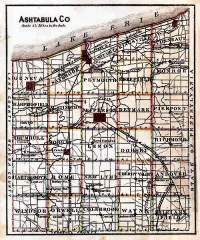
Ashtabula was formed June 7, 1807, from Trumbull and Geauga, and organized January 22, 1811. The name of the county was derived from Ashtabula river, which signifies, in the Indian language, Fish river. For a few miles parallel with the lake shore it is level, the remainder of the surface slightly undulating, and the soil generally clay. Butter and cheese are the principal articles of export, and in these it leads all other counties in the amounts produced. Generally not sufficient wheat is raised for home consumption, but the soil is quite productive in corn and oats. In 1885 the acres cultivated were 129,992; in pasture, 150,152; woodland, 62,223; lying waste, 3,700; produced in wheat, 234,070 bushels; corn, 382,238; oats, 677,555; apples, 587,385; pounds butter, 1,042,613; and cheese, 354,400. School census, 9,441; teachers, 543. Area 720 square miles, being the largest county in Ohio. It has 191 miles of railroad.
County Population as of 1880
| Townships | and Census | Townships | and Census | ||
|---|---|---|---|---|---|
| 1840 | 1880 | 1840 | 1880 | ||
| Andover | 881 | 1168 | Monroe | 1326 | 1459 |
| Ashtabula | 1711 | 5522 | Morgan | 643 | 1223 |
| Austinburg | 1048 | 1208 | New Lyme | 527 | 893 |
| Cherry Valley | 689 | 698 | Orwell | 458 | 973 |
| Conneaut | 2650 | 2947 | Pierpont | 639 | 1046 |
| Denmark | 176 | 697 | Plymouth | 706 | 780 |
| Dorset | 0 | 613 | Richmond | 384 | 1011 |
| Geneva | 1215 | 3167 | Rome | 765 | 668 |
| Harpersfield | 1399 | 1116 | Saybrook | 934 | 1384 |
| Hartsgrove | 553 | 798 | Sheffield | 683 | 688 |
| Jefferson | 710 | 1952 | Trumbull | 439 | 960 |
| Kingsville | 1420 | 1621 | Wayne | 767 | 835 |
| Lenox | 550 | 820 | Williamsfield | 892 | 974 |
| Colebrook | 0 | 956 | Windsor | 875 | 964 |
Historical Collections of Ohio
By Henry HoweVol. I – 1888
Ashtabula County page 261